
RANGELAND MONITORING APPS: MAKING COLLECTING DATA EASIER
1. LandPKS, free
Allows you to monitor soil/ site characteristics, photos, locations, cover, and dominant species.
Prompts you to take photos facing N, E, S, and W. Also has simplified monitoring techniques to assess cover. Easy to use and picture-based (versus plant species or scientific-name based).
The app uploads data to an online portal into a spreadsheet. Very handy, but data is public. You name the data, however, so unlikely someone would search and find your specific name.
https://www.landpotential.org/landpks.html
2. PastureMap, $$
Tracks grazing moves, duration in a pasture, location of water tanks, gates, monitoring points, stocking density, and more. Allows you to draw the site and shape of your pasture in on digital maps and record how long you are in each pasture. Can also track the grazing records for each herd and calculate Average Daily Gain.
https://pasturemap.com/how-it-works/
3. CowPoopAnalyzer, free
Allows you to assess forage quality based on cow pies. Not kidding! You take photos of a cow pie, and then the app compares your photo to pictures where the crude protein and digestibility is known for an estimate of these attributes in your pasture.
Look for “CowPoopAnalyzer” in your App store.
4. GrassSnap, free
Allows you to take photos of a pasture o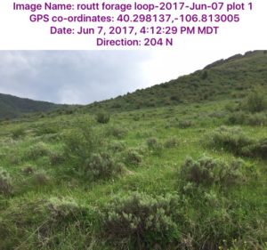 r range (see below). Photostamps the photos with the location, direction, and dates the photo. Appears to stretch photos on your phone, but they are OK when you download to your phone, print or save.
Other features on the app were developed for Nebraska and not applicable in CO. https://extension.unl.edu/statewide/centralsandhills/grasssnap
5. The Colorado Resource Monitoring Initiative & Monitoring on Public Lands
If you are primarily concerned with monitoring on public lands, it is IMPERATIVE you check with whatever agency manages the allotment (Forest Service, BLM, State Lands). It would be best to calibrate your methods with methods they are using.
The Colorado Resource Monitoring Initiative features a comprehensive list of methods approved by all agencies. This is a good place to start.
Monitoring Manuals and resources from the Colorado Resource Monitoring Initiative are available at:
http://www.coloradocattle.org/coloradoresourcemonitoringinitiative.aspx
Thinking about Monitoring? Need Help?
If you need help deciding on methods, and weighing pros and cons, Extension can help.
Contact regional specialist in range management, Retta Bruegger at (970) 988-0043 with questions.
Download a PDF version of this webpage?
[embeddoc url=”https://rangemanagement.extension.colostate.edu/wp-content/uploads/sites/42/2017/12/Additional-resources-NEW.pdf” width=”70%” height=”70%” download=”all”]
Need help understanding technical methods?
This fact sheet has information on Line-point intercept
[embeddoc url=”https://rangemanagement.extension.colostate.edu/wp-content/uploads/sites/42/2018/05/Final-LPI-handout-Bruegger-8.24.17.pdf” width=”70%” height=”70%” download=”all”]